For years I have heard about the beautiful Apostle Islands off the shore of Bayfield, Wisconsin. In fact, Tom and I had talked several times about taking the Saralynn here. It's hard to believe we are actually here now.
We left Bayfield on a foggy Monday morning. As we headed out the fog thickened and we were running slowly on radar. All of a sudden these kayakers appeared near us. Not a safe day to be kayaking between islands.
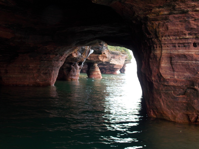
Taking advantage of the calm water, we decided to day anchor off Devil's Island, the farthest north island, and explore the "sea caves". This can only be done on a dead calm day since the anchorage north of the island is wide open to the lake. As we approached Devil's Island the fog lifted and we were blessed with a beautiful day. The dink performed perfectly taking us along the shoreline and in and out of several "sea caves" which are actually large solution pockets in the sandstone cliffs. The colors of the rock and the carved formations are wondrous. Be prepared! I could not stop the camera!! For those who would like to see more of these amazing sculptures, I'll post them on a separate blog.
 |
| Inside one of the sea caves. |
 |
| Northern corner of Devil's Island |
 |
| Raydiance patiently waiting for us to return. |
 |
| Amazing sandstone sculptures |
 |
| Lighthouse at Devil's Island |
Leaving Devil's Island was tough to do, but we pulled ourselves away and went to Raspberry Island next. The National Park Service has done a wonderful job restoring the lighthouse to its state in the 1920's and a very personable ranger, Jim, was on hand to give tours. The lighthouse was essential to freighters when Bayfield was a major port. Today, the large fresnell lens has been removed from the tower and replaced by a very small, but intense, light structure. As Jim remarked,, it may be efficient but no novels--love stories, mysteries, etc.--will be inspired by the new light.
 |
| The new light on Raspberry Island |
 |
| The original lighthouse, now restored. |
 |
The spacious dining room
with beautiful floors and woodwork. |
 |
View from the catwalk around the tower of old
Raspberry Lighthouse |

Sunset at Raspberry Bay
Our anchorage that night in Raspberry Bay on the mainland proved to be a bit rocky, but we held tight. The next morning we moved to East Bay off Sand Island--the island farthest west. Again we explored the sandstone sea caves on the northern end by dinghy. Although not as numerous, they were more accessible to enter and wind through. Many people were doing so in kayaks. Excursion boats would bring them to the island and wait for them as they explored. We planned to hike to the lighthouse, but the sign below changed our minds. Instead we took the dink around to view it from the water.
 |
| Sign that discouraged hiking! |
 |
I looked these up in our bird book and
I think they are called common merganser. |
 |
| Ready to hike, but not with badly behaving bears. |
 |
| Sandstone sculpture on Sand Island. |
 |
We didn't see any bears as we dinked to the lighthouse,
but this bald eagle was magnificent! |
 |
| Sand Island Lighthouse |
 |
| Sand Island lighthouse close-up. |
The anchorage in East Bay was very peaceful, a welcome change from the night before. Wednesday and Thursday strong storms were forecast so we made reservations at Madeline Island Yacht Club. The storms never materialized, but we enjoyed spending a few days on Madeline Island--the largest island in the chain but not part of the NPS. However there are two large beach parks on the island, one run by the NPS and the other by the town. Wednesday was my birthday and we celebrated with dinner in town and ice cream. We were going to have dinner at Tom's Burned Down Cafe, but arriving we realized this was only a bar--a very unique bar. Unfortunately I forgot my camera. Thursday we rented scooters for a few hours and buzzed around the island. This was my first experience driving a scooter and I found turning challenging. Tom has a video which I am glad cannot be put on the blog!
 |
Big Bay NPS Park
The water was cool but "swimable"
compared to most Lake Superior water |
 |
| Scooter Queen |
Friday we decided to leave Madeline Island and check out Stockton Island, the second largest island, to see Julian Bay and hike for a few miles. The bay is beautiful with a horseshoe sand beach and clear water. We started on the hike, but before we had gone a quarter mile we were swarmed by black flies. Nothing discouraged them, so we surrendered and headed back the safety of the boat.
 |
| Raydiance at anchor in Julian Bay |
 |
| Flies!!!!! We surrender! |
 |
| Shoreline of Julian Bay |
We spent the night at a NPS dock on Rocky Island so that we would have a good jump on our trek across the lake to Silver Bay the next day. We tried to give hiking a second chance, but the flies there were every bit as tenacious as at Stockton. So we settled in for the evening with our books and screens.
 |
| Dock at Rocky Island |
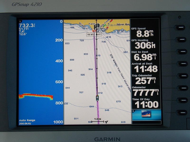
The winds were supposed to stay 5-10 from the north, but during the night they increased and shifted to the northeast. The two sailboats at the dock with us left early in the morning (3:00 a.m.) but we stayed and rocked a bit. Saturday morning, we said good-bye to the Apostles and the south shore of Lake Superior and headed north to Minnesota.


.JPG)


